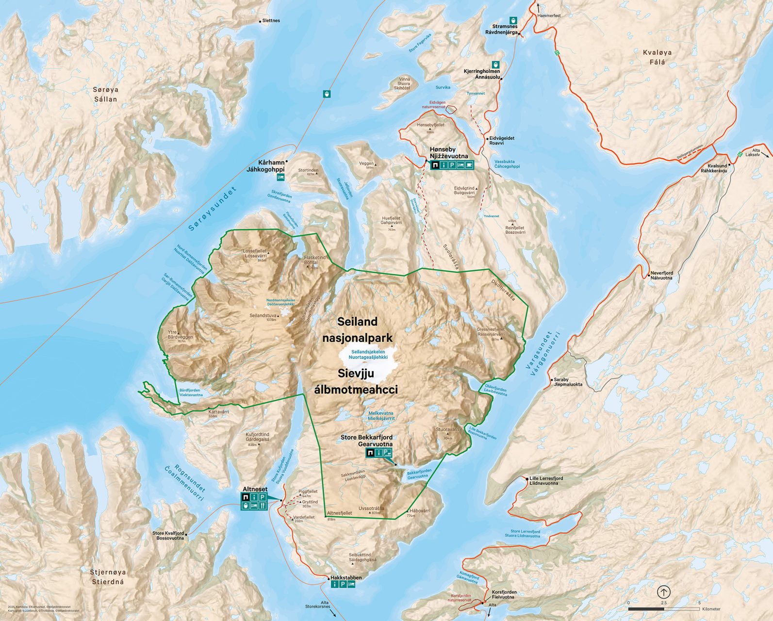
Access points
The national park has two access points: Hønseby on the north side and Altneset on the south side of Seiland. You can reach these places by public transportation, and they offer accommodation options. Additionally, there is some facilitation in Store Bekkarfjord. Here, a quay is available during summer, accessible by private boat transfer.
Winter on Seiland
Seiland National Park is most frequently visited during the snow‑free season from June to September. Winter visits require thorough planning, preferably in collaboration with local tour operators. There are no groomed or marked trails on Seiland in winter.
Check avalanche conditions and terrain steepness maps on varsom.no if you plan to go skiing or snowshoeing. Avoid skiing alone in the mountains unless you have experience with winter travel in northern coastal areas.
Bildetekst hentes fra tittel i slideshow
Bildetekst hentes fra tittel i slideshow
Hønseby on northern Seiland
To reach northern Seiland, you take the ferry from Strømsnes (9 km south of Hammerfest) to Kjerringholmen on Seiland. Ferry schedules are found at snelandia.no. From Kjerringholmen travel 19 km by road to Hønseby. The road is narrow and winding but offers spectacular views!
At Hønseby, you will find a grocery store and options for accommodation and boat rentals. The store has an indoor exhibition about the national park, and visitor toilets. Close to the store there is a small parking lot for hikers and outdoor information about the park. From here, a marked trail begins, stretching 9 km to the national park border, which is a good starting point for longer hikes into the park. A shorter alternative is to follow the trail 2 km to a trail register box and turn back here. From this point you have a good view of Hønsebyfjorden and the sound of Sørøysundet, and you can also continue on an unmarked 1 km trail down to Storvannet lake.
The trails are summer trails, and both the trails and some of the markings will be covered with snow during winter (approximately from October/November to May/June).
Altneset on southern Seiland
To reach Altneset on southern Seiland, take the express boat/combi ferry from Alta town (Alta express boat terminal) or from Storekorsnes. See snelandia.no for boat schedules, and note that many departures require pre-booking. From Altneset you can in summer hike marked trails to Vardefjellet (232 masl), Gryttind (307 masl) and a forepeak of Piggfjellet (405 masl) . Gryttind and Piggfjellet are excellent starting points for longer hikes into the national park. The same applies to Altnesdalen and Sommarsetdalen valleys. Along the fjord, a narrow paved road winds 8 km south to Hakkstabben, offering beautiful views towards Rognsundet sound and Stjernøya island.
Several companies and private hosts provide accommodation and boat rentals along the Altneset–Hakkstabben stretch. These services must be booked in advance. Please note that there are no grocery stores on southern Seiland.
Bildetekst hentes fra tittel i slideshow
Bildetekst hentes fra tittel i slideshow
Store Bekkarfjord
In Store Bekkarfjord, visitors will find facilities including a public floating dock, a designated fire pit, information boards, and an art installation illustrating the history of the area. The floating dock is owned by the national park and is in place from 23 June until October/November each year.
There is no public transport to Store Bekkarfjord, but several companies offer boat trips into the fjord. Store Bekkarfjord is located inside the national park and serves as an excellent starting point for exploring the area.
If you begin on the north side of the Melkelva river (near the floating dock), you can hike up toward the Melkevatnan lakes. Starting on the south side of Melkelva, a rewarding day hike leads across to Altneset.
There is no bridge across Melkelva, and attempting to cross the river can be extremely dangerous. Plan your route in advance and make sure to start on the side you intend to hike from.
Other hikes in the park
If you have access to a boat, many additional hiking opportunities open up. Bårdfjorden offers relatively easy terrain leading into the Bårdfjorddalen and Pederdalen valleys. In Jøfjorden, you can hike toward the Seilandsjøkelen glacier from the Breihovddalen valley.
Consult local experts about route choices before setting out. There are many obstacles that do not appear on the map, such as large boulder fields, impassable block terrain, cliffs, steep slopes, and rivers that cannot be crossed. It is said that it is difficult to get lost on Seiland, but easy to get stuck.
If you prefer more accessible hikes along marked trails, the Hammerfest and Surroundings Trekking Association has published route descriptions on ut.no for trails to Tindstua, Eidvannet, and Tyvvannet, located north of the national park.
Bildetekst hentes fra tittel i slideshow
Bildetekst hentes fra tittel i slideshow
Seilandstuva
Seiland’s highest peak, Seilandstuva (1,078 m), is a long and demanding hike suitable only for visitors with substantial mountain experience. The summit can be reached from several fjords, with Kufjordbotn in Store Kufjord being the most commonly used starting point.
Be aware of the crevasses on the Nordmannsjøkelen glacier, which lie around parts of the summit area.
Seilandstuva is part of the Struve Geodetic Arc, and the summit cairn was built by Struve’s survey team in 1847. It is said that they needed five attempts to complete their measurements from Seilandstuva due to sea fog, wind, and snow. The summit is visible from seven other points in the meridian arc, making it an important triangulation site.
The Struve Geodetic Arc played a crucial role in determining the Earth’s size and shape, and today it is listed as a UNESCO World Heritage Site.